


Inversions & 3D Geophysical Models
Click to explore our way of turning data into models and visualize geoscience like never before ![]()
Inversions & 3D Geophysical Models
Click to explore our way of turning data into models and visualize geoscience like never before ![]()
Data can be also integrated to an existing model and improve its subsurface imaging. The addition of new information is always a powerful strategy to polish knowledge and achieve an assertive result as the integration and improvement cycles significantly increase the model’s performance.
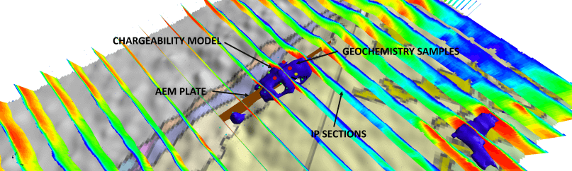
A good integration of data is critical to successful mineral exploration and GSM can help you bring light to your data.
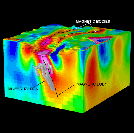
Magnetic data can provide much more than geophysical anomalies. Structural analysis using products coming from magnetical data processing can provide information about size, shape and orientation of geological formations.
Faults, fractures and folds that are associated with mineralization can be mapped by techniques that can be used in different scales, from fine to coarse, to identify edges or boundaries in the magnetic anomalies. Worms or Multiscale Edge detection can be used to improve knowledge of usual geological environments.
For areas with complex magnetic structures or strong magnetic anomalies, PPDRC filters (Phase Preservation Dynamic Range Compression) provide information not achieved before. Enhancing weak magnetic anomalies by monogenic filters allows the extraction of weak signals that are buried in the noise earlier. Smaller (but important) structures can be mapped and improve local structural understanding, improving the resolution and accuracy of magnetic data interpretation, which can lead to significant savings in exploration costs.